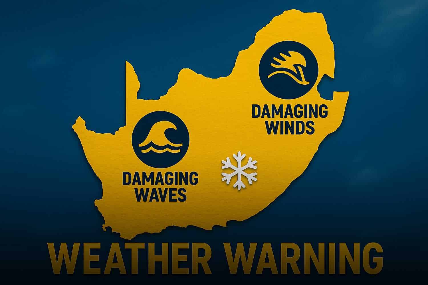
The South African Weather Service (SAWS) has issued yellow level 2 warnings for parts of the country on Friday, 20 June 2025, alerting the public to potentially dangerous weather conditions.
Weather warnings for Friday, 20 June 2025
These alerts are part of an impact-based warning system designed to help people understand how weather could affect them directly.
The weather warnings are focused on damaging winds and waves along the southern and eastern coastlines and parts of the interior.
Specifically, SAWS warns that strong winds could cause damage to both formal and informal homes in areas like Kouga and Nelson Mandela Bay in the Eastern Cape.
These winds may also disrupt marine navigation, especially between Plettenberg Bay and East London.
In addition to the wind warnings, the coastal zone between Saldanha Bay and East London will be affected by damaging waves.
These waves pose a threat to small boats, which may take on water and possibly capsize, and could also disrupt operations at ports and harbours.
These sea conditions are expected to persist into Saturday morning (21 June 2025).
There are no fire danger warnings in place for this day.
Seasonal weather: What to expect this month
According to the latest Seasonal Climate Watch issued by SAWS on 4 June 2025, the El Niño-Southern Oscillation (ENSO) is currently neutral and is expected to stay that way for the foreseeable future.
This means that South Africa is not likely to experience extreme weather patterns linked to El Niño or La Niña this winter.
Winter and early spring in South Africa typically bring rainfall to the southwest and the coastal regions.
For mid-winter, SAWS predicts above-normal rainfall in the southwestern and eastern coastal areas.
However, as the country moves into late-winter and early spring, the southwest is expected to see below-normal rainfall, while the eastern coastal areas are likely to continue experiencing more rain than usual
Daytime temperatures are expected to be above-normal in most parts of the country during this period.
However, some southern coastal areas may have colder than usual temperatures, with maximum temperatures staying around 10°C or below, especially in the Western Cape interior and the Namakwa District of the Northern Cape.
These changing conditions could affect water supplies, health, and agriculture.
For example, warmer temperatures may increase the demand for heating, while dry conditions could limit access to water in drought-affected areas like parts of Mpumalanga and the Eastern Cape.
SAWS continues to advise all residents and sectors—particularly in water, health, and agriculture—to monitor forecasts closely and take necessary precautions.
Communities in affected areas should prepare for strong winds, damaging waves, and cold temperatures, and avoid going out to sea or taking part in outdoor activities during warning periods.